Showing posts with label County Kilkenny. Show all posts

Dunmore Cave, County Kilkenny

If you enjoy our blog and you'd like to receive daily updates about Ireland's great heritage sites then please consider following us on FacebookTwitter and Google+.


Dunmore Cave is located approximately 11km north of Kilkenny City, near Castlecomer. The cave contains around 300m of known passages and caverns. In terms of geology, Dunmore Cave is a rare example of a cave that was formed directly by glacial meltwaters.


Although not a particularly large cave system, Dunmore has a number of great examples of calcite formations like stalagmites and stalactites. However my interest in the cave comes from its dark history.
Located in the north of County Kilkenny, in a region of the ancient Irish kingdom of Ossory, Dunmore Cave was situated right in the middle of a stomping ground between the Viking powerbases of Dublin, Waterford and Limerick. The Vikings of Ireland were not one people with a united ambition and government, but were instead rival powers who regularly came into conflict with one another.
The cave at Dunmore has a chilling story to tell. The Annals record that over 1,000 people were massacred here by the Vikings. It is said that the Vikings from Dublin were en route to attack rival Vikings at Waterford circa 928 AD. They raided the surrounding land and found that a large number of people (mainly women and children) were hiding in the cave at Dunmore.
In an attempt to drive them from the cave, they lit large fires hoping that it would force those taking shelter to flee the smoke so that they could be easily captured and sold in the slave markets. However the fires were too large and burned all the oxygen in the deep cave with many suffocating to death. Antiquarians in the 18th and 19th centuries collected large quantities of human remains from within the cave, presumably those of the poor people who were massacred in that raid.
It appears that some Vikings returned to the site later to conceal their wealth. In 1999, a small hoard of silver and copper-alloy items was discovered in a cleft deep in the cave. The hoard was dated to 970 AD. It consisted of silver ingots and conical buttons woven from fine silver.
These precious objects were found with a luxurious silk garment. The dye that coloured the garment purple was reserved for the highest ranking members of society, and it was derived from the purple murex snail that can only be found on the north coast of Africa, evidence of the incredible trading network of the Vikings. Perhaps the owner of the hoard concealed it there, hoping that the cave’s dark reputation would keep it from prying eyes, but they were never able to return to retrieve it. It is also possible that they left it as an offering to chthonic (subterranean) gods or spirits.
Today Dunmore Cave is a really rewarding place to visit with a fine visitor centre. You can enjoy great guided tours that inform you about the history, archaeology and geology of this fascinating site. You can find information about opening hours and entry fees by visiting here http://www.heritageireland.ie/en/south%2Deast/dunmorecave/.
If enjoy my blog and you'd like to support us try our acclaimed series of audioguides to Ireland’s heritage sites, they are packed with original music and sound effects and a really fun and immersive way of exploring Ireland’s past. They are available from AbartaAudioGuides.com and a number are absolutely free to download.
If you’d like to receive daily updates about great heritage sites then please consider following us on FacebookTwitter and Google+.
All photographs © Neil Jackman /abartaaudioguides.com

Granny Castle, County Kilkenny

 For daily updates on Ireland's wonderful heritage please follow us on Facebook, Twitter, Google+ and Instagram

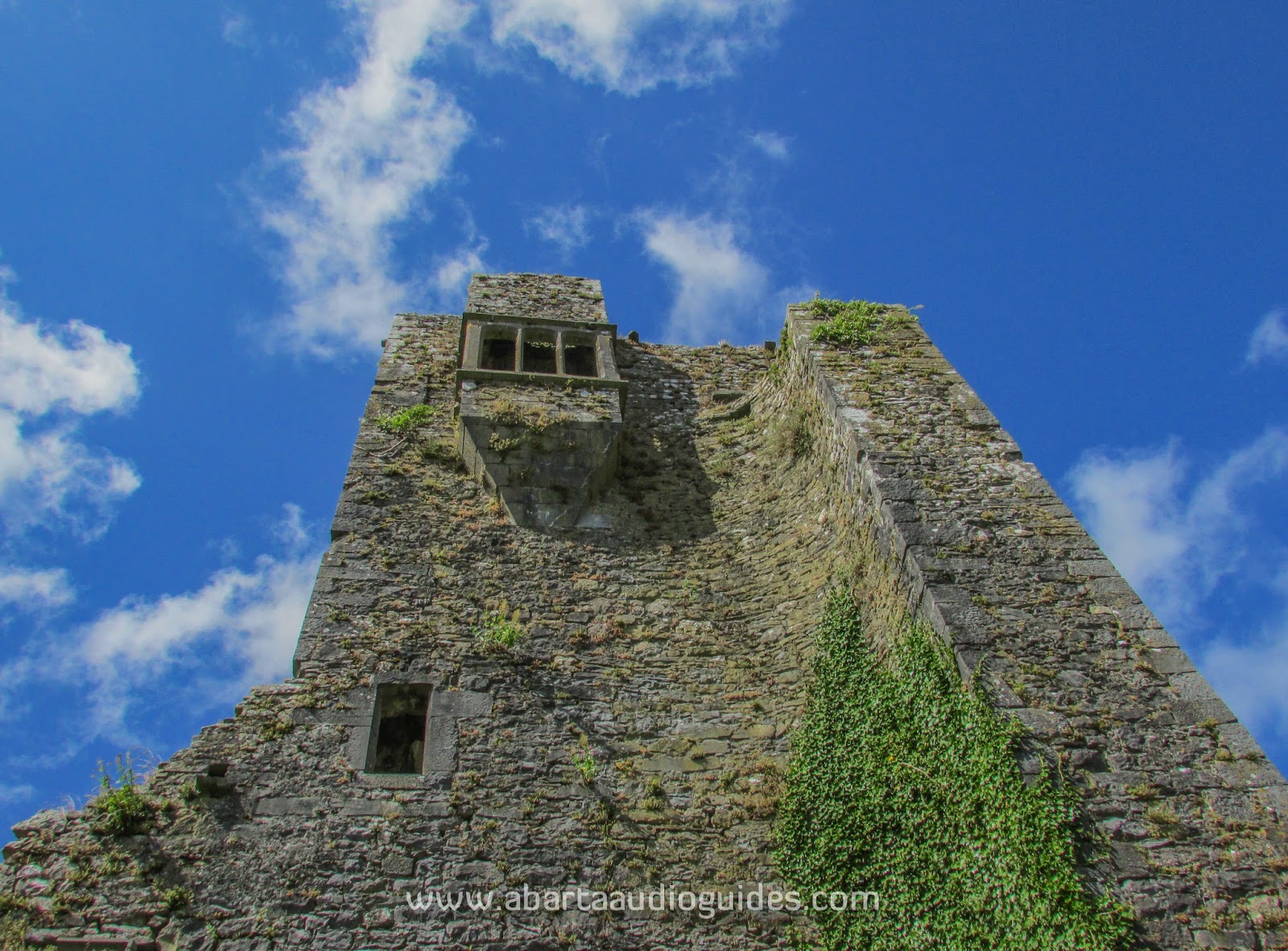
Granny (also known as Grannagh) Castle is located on the banks of the River Suir in south County Kilkenny, just 5km outside Waterford City. The castle was originally constructed by the de la Poer family in the mid thirteenth century, however the de la Poer's (who later became Anglicized to Power) fell out of favour with King Edward III, and forfeited much of their land.

The castle and its lands were given to the powerful Butler family in 1375 and they are responsible for most of the visible remains. The square enclosing wall with its projecting towers at the south-west and south-east angles has a look of the late thirteenth – early fourteenth centuries. The main tower of the castle appears to date to the fifteenth century and is in keeping with the fashion for tall fortified tower houses, that both served as a means for defence and an illustration of the wealth, power and status of the lord.

The tower-house was a popular style of defensive structure among all of late medieval Ireland with both the Anglo-Norman population and the Gaelic Irish gentry adopting it. It is most numerous in the southern half of Ireland, particularly in Counties Kilkenny, Wexford, Cork, Tipperary, Limerick, Clare and Galway. Tower houses are particularly common in the region under Anglo-Norman control known as The Pale, as in 1429 the English government paid £10 subsidy (a substantial fee at the time) to encourage people to build these defensive structures at a time when many of the Gaelic tribes were becoming resurgent again. The fine oriel (projecting bay) window probably dates to the late sixteenth or early seventeenth century. 

Granny Castle is very handily located just off the N24 Limerick - Waterford Road about 5 minutes outside Waterford City. It is visible to the right as you approach Waterford on the N24, just before the M9 Motorway. Take the right hand turn before the M9 motorway roundabout. When you turn onto this road there will be a small lane to the right which leads down to the castle. There is limited parking along this lane.   

If you’d like to keep up with daily images and information about Ireland’s fantastic heritage sites please consider following Neil’s company Abarta Audioguides on FacebookTwitterInstagram or Google+.

If you’d like to support us please consider downloading an audioguide from abartaaudioguides.com: they are packed with great facts, information, stories and legends from Ireland’s iconic sites. They are designed to be fun and informative whether you are visiting the sites or from the comfort of your own home, so if you are looking to escape to the Court of Brian Boru the next time you are doing household chores, download one of our guides and let Abarta whisk you off to ancient Ireland!
 

All images © Neil Jackman/Abarta Audio Guides

Jerpoint Park, County Kilkenny

I've worked in archaeology in Ireland since 1999 and I've visited a number of sites around the country, however last Thursday was the first time I visited Jerpoint Park in Co. Kilkenny and I have to lay my cards out on the table early – I was really taken with the place, in fact it might well be one of my favourite heritage sites in Ireland.

The site is of immense archaeological and historical significance. Jerpoint Park encompasses Newtown Jerpoint, a deserted medieval town of major importance. The town was founded in around 1200 AD at a crossing point of the River Nore and is located very close to the more famous Jerpoint Abbey (visible in the background of the image above). The town was probably founded by a tenant of William Marshall named Griffin fitz William brother of the famous Norman warlord Raymond le Gros (for more on some of Raymond's exploits take a look at our Baginbun post). It was a thriving and vibrant town constructed around two intersecting roads (one running north–south, the other east–west). The town was divided into around 22 burgage plots (land and buildings in a town held in tenure by a noble or lord and rented out), these plots would have had houses at least partly constructed by stone and the remains of a number of these survive today as piles of stone inside the earthen banks of the burgage plot.   
Look carefully at this image and you can see the undulations in the ground showing the outlines of burgage plots and houses
The town also had at least two watermills, and is said to have had a marketplace, a brewery, taverns, a courthouse and a tannery. Near the centre of the town you can see the remains of an urban towerhouse, probably the home of a wealthy merchant, the towerhouse would have offered a defensive position for the town during raids.

Perhaps most significantly the town also has the remains of St. Nicholas' Church. Constructed around the time that the town was founded in around 1200 AD, the church still survives well today and is the most visible and tangible remains on the site. The church has evidence of a number of alterations over the centuries, of which the construction of a very unusual rood screen and a domestic tower where the priest would have lived in the 15th Century is the most notable.
The Medieval Church of St. Nicholas
Historical records still show the church in use in 1622, but it probably fell into disuse and disrepair in the late seventeenth century.

The church is surrounded by a graveyard with a number of graves dating from the medieval times to the nineteenth century. The most significant by far is the grave of St. Nicholas of Myra himself, yes, Father Christmas is buried at Newtown Jerpoint in County Kilkenny (don't tell the kids).
It is thought that his remains were brought back from Bari in Italy by two knights returning from a crusade. They reburied him in this fine tomb at St. Nicholas' Church in the medieval town as they thought it would be a safer location for the remains of such an important figure.
The tomb of St.Nicholas

If you look closely at the photo of the tomb of St.Nicholas you can see depicted the heads of the two knights that brought his remains to Newtown Jerpoint. Having the tomb of such an important saint would have brought great wealth and prestige to the town, as pilgrims would have travelled huge distances to pray at the site of the mortal remains of St. Nicholas.

The graveyard alone is worth exploring, a large number of the gravestones, both medieval and post-medieval, are interesting for the craftsmanship and symbolism. For example if you look at the picture of a medieval graveslab below you can see how wonderfully carved it is, with the unusual depictions of a boat (upper left corner of this picture) and a sun (difficult to make out but upper right opposite the boat), you can also see a cross surrounded by intricate decoration that appears to end in fleur de lis typically associated with France. Latin script surrounds the stone. It is tempting to spend time looking at some of carvings like this one, trying to decipher the message in its symbolism.

Near the churchyard you can find the burial plot of the Hunt Family in a small enclosure, tombs there date from 1771–1975 and some are beautifully carved showing the high level of skill and craftsmanship of the stonemason.

The town was formed, and named after, the bridge that crossed the River Nore at the junction with the smaller River Arrigle. The name Jerpoint itself means Nore Bridge.
Very little remains to be seen of the bridge today, but you can make out its original position where a large number of stones in the river force the waters to churn and break.
In the picture below follow the river along and you will see a rougher area of water between two trees - this is the possible location of the bridge
The River Nore that forms the Northern boundary of the town
The town was deserted probably in the later part of the seventeenth century. It seems that the bridge either fell into disrepair, or a newer bridge was constructed elsewhere on the Nore. This meant that the main road no longer passed through Newtown Jerpoint, and that would have caused a great loss in revenue for the town, perhaps starting its decline. The town eventually became abandoned, and the lands came into the possession of the Hunt family who leased this area to the Earl of Belmore. He constructed the beautiful Belmore House in around 1780 as a hunting lodge. This fine house is now the family home of the site owners Joe and Maeve O'Connell. Joe took me around the site and it was a fantastic experience as he pointed out many details that I could have easily missed, and was full of stories about Newtown Jerpoint, it was a really enjoyable guided tour experience.

Today Jerpoint Park is open to the public for guided tours, please see their website at http://jerpointpark.com/  for more details. Entry fee is a very reasonable €8 per person with free entry children under 12.
I honestly cannot do this place justice in writing, it has a unique and tranquil atmosphere where you can feel more connected to the past than at any other site in Ireland. Although the remains of the houses, taverns, mills and market now only survive as bumps in the field, when you are there it is easy to become immersed in the atmosphere and picture what life was like when it was a thriving town nearly 800 years ago.


Knockroe Passage Tomb, County Kilkenny

Knockroe Passage tomb is located in a picturesque setting on the slopes above the Lingaun River and old slate quarries which were abandoned in the early 1900's. The site dates to around 3,000 BC and has many similarities to the far more famous examples such as Newgrange and Knowth in the Brú na Bóinne complex in County Meath.
Originally Knockroe would have been a similar tomb to Newgrange, albeit on a smaller scale. It is likely that it too would have had an earthen mound surrounded by large kerbstones. However unlike Newgrange, Knockroe has two burial chambers, located at the eastern and western sides of the feature. These tombs are exposed, and had long ago lost their earthen cover.  Many of the stones lining the passageways of these tombs at Knockroe are highly decorated with megalithic art such as spirals, hollowed 'cup marks', and zig-zags. You can still find them in their original locations, and when you see them it is impossible not to wonder about the possible meaning of the decorations - was it purely decorative or did it have a deeper symbolism, and what messages may be in that symbolism? You can also still see the quartz which possibly would have formed a wall around the entrance to the passageways.

Also like Newgrange, Knockroe is aligned with the Winter Solstice. Every year around the 21st December people gather at Knockroe to witness the sun setting in perfect alignment with the length of western tomb.

Knockroe is one of a group of tombs located in this region, all of which are aligned with the large
mound on the summit of Slievenamon in County Tipperary. Knockroe is one of those wonderful sites that you can't help to keep thinking about long after your visit, without being encumbered with its earthen mound, Knockroe is like the stony skeleton of a Neolithic passage tomb.

To get to Knockroe from Carrick on Suir, take the R697 going North, then take the left hand turn for the R698 and continue down this road, until you come to a crossroads, go left at this crossroads and continue straight on, through another smaller crossroads, after this take the next left and drive carefully down this road. The site will be located down this lane. The lanes are narrow and you may have to park your car at the top of the lane. The site is fenced off and situated on relatively dry ground but boots or reasonably sturdy footwear is still advised. The site is free to enter


Kells Priory, County Kilkenny

When you first encounter Kells Priory, you'd be forgiven for thinking that this is a castle given its strong defensive walls and towers, but Kells Priory was a monastery. It is superbly well preserved, and is one of the most striking and unforgettable monastic sites in Ireland. 

The Priory was founded in 1193 by Geoffrey FitzRobert, brother in law  to the famous Strongbow - Richard de Clare, leader of the Norman forces in Ireland. It was given to the Augustinian Canons, the biggest religious order in Ireland at the time.


The site itself was attacked and burned on three separate occasions, by William de Bermingham in 1252, then by Edward Bruce on Palm Sunday 1326, and then by a different William de Bermingham in 1327. The large walls and towers that enclose an area of approximately three acres possibly date to immediately after this turbulent period in the middle to late fourteenth century.


The Priory is situated on low lying ground near the King's River, which probably had a number of mills that provided flour and economic muscle to the Augustinian priors at Kells. The large walls that surround the site are nearly 6m in height, and over 1m thick with regular loops for arrows. It is clear that the Priory would have been well defended. Each of the towers along the walls served both a residential and defensive purpose. The first large enclosure that you enter is known as 'The Burgess Court' and it is thought that it provided a secure place for the lay population to take shelter during attack. The walls surrounding the inner part of the Priory are thought to have been constructed earlier.
The Church at Kells Priory dates to the earlier part of the activity, probably around the early part of the thirteenth century. It appears to have been altered and extended a number of times over its history.
The Priory is truly one of Ireland's hidden gems, a great place to visit and you'll often find you have the place to yourself. You'll find it about 15km south of Kilkenny City, near the village of Kells, signposted off the R697.

There are a number of other great sites in the locality, including the deserted medieval town of Newtown Jerpoint, the Neolithic Passage Tomb of Knockroe  as well as Jerpoint Abbey and Thomastown itself. 

I hope you enjoy this blog, we're trying to cover as many sites as we can across Ireland. If anyone has any suggestions about sites you'd like us to cover please do leave us a comment. If you enjoy information and images of Irish heritage sites then do follow us on Facebook, Twitter and Google+ If you'd like to support us then please consider downloading an audioguide to one of Ireland's wonderful heritage sites. They are packed with original music and sound effects and are a great way of experiencing the story of Ireland. They only cost €1.99 and are fun whether you are at the site, or listening from the comfort of your own home. If you enjoy stories of the turbulent medieval period in Ireland try our guide to Viking and Medieval Dublin, visit us at www.abartaaudioguides.com for free previews and to download your free audioguide to the Rock of Dunamase  or the free audioguide to the wonderful heritage town of Kells in County Meath